August to do list:
- Get to Allen Texas before Mark goes on holiday – done
- Get to San Antonio and meet Sue at the airport – done
- Have a great Texas road trip with Sue – done
- Catch up on admin, plan route through Mexico, check schedule for Sue’s next visit in Peru, set up another GPS tracker, backup photos, pack maps and supplies brought over by Sue, bike service – done
- Catch up on blog – right, where was I? Ah yes . . .
After getting a world wide top 100 place in the Strava July Distance Challenge, I was hoping to have an easier day on the 1st of August. But the road I’d been traveling along for almost a 1000 miles was becoming increasingly bike unfriendly – ie it was going to turn into a freeway (ie motorway) well before my next stop on the Reading Reunion tour.
Navigation for the first 2000 miles was easy – three roads (Dalton, Richardson and Alaska highways) and that was it. After that, the rest of Canada and North Dakota were sufficiently sparsely populated that the direct routes were relatively quiet, and without any bike restrictions. But after Fargo where my route went due south, the towns got bigger, and the direct roads became Interstate Freeways – ie motorways where bikes were banned. Luckily I found Route 75 – an interstate road that went due south from Fargo, all the Way to Texas – perfect. When I say “found” I mean on the map – trying to get on the actual road was not so easy. My scenic route through suburban Fargo/Moorhead did not escape the eagle eyes of Mr Minto:

(My daily Strava updates can be seen here: Strava )
When I did eventually pick up signs to Route 75, there were further detours caused by extensive roadworks, and even a train that parked on a level crossing for what seemed like ages. Just when I thought I was past the worst of it, the bridge over the Interstate 94 was entirely closed, with a detour heading back to my suburban scenic route. By now it was almost 6pm, so rather than go back to where I’d come from, I waited a short while for the workmen to finished for the day, and pushed my bike past the bulldozers. My aversion to detours is a curious thing – you’d have thought that after cycling 1000’s of miles, a few extra miles here or there wouldn’t make a difference, but I find myself with the attitude of a non-cyclist – “Cycle 2 miles? That’s way too far!”


But after a shaky start, Route 75 served me well. It was everything from a country road (with no shoulder) to a city bypass with 2 or even 3 lanes and a full hard shoulder:


(yes, that car really did pull into the outside lane to pass me, even though I already had more than enough space on the shoulder!)

As with the Dalton and Alaska highways, there were mile posts – a small sign every mile counting down the miles. While route 75 is an inter state route like the Alaska highway, the mile posts here counted down the number of miles until the next state, not the end of the road. This helped break the journey down into state sized chunks. Though they were sometimes a curse – on the long days where I was slowing down because of the heat and the head wind that was bringing it up from the south, it sometimes seemed to take forever for the next post to appear, or they were a reminder of how little distance I’d covered in, say, the previous hour.
Because Route 75 was a relatively major road, it would have motels, restaurants and gas stations + convenience stores along it in any sizeable town. So not only was it easy to follow, but there was a minimum of time spent looking for food or aircon.
While short sections of dual carriageway with slip roads were OK (eg around Sioux City), as I approached the Texan border, it was going to be like this all the way to Allen. It was also the 1st of August, and as I’d made up so much distance in July, the thought of taking some quiet back-roads was appealing. Looking at the large scale state map and google maps I worked out what looked like a direct route south from Atoka.
It started out OK – I got an early start, made good progress while the temperature was in the relatively cool low 30s C, and found a terrapin that I moved from the road before it got squashed like many others I’d seen:

But my paper map had too small a scale to show the detail of the back roads – like when the tarmac road I was on split into two dirt tracks. As I had already covered 20 miles, I was not that keen to go back, so I took the south turning and carried on. The map did show a river running east-west and some sort of road on the other side, but not whether there would be a bridge to cross this river, or even if the road on the other side was rideable. As I headed down the road to find out if it was a dead end, the wildlife continued. I saw a snake – just a small one, and too fast to capture on camera. There were also Cicadas – a small insect with a cricket-like mating call so loud it disables its own hearing to prevent it from being damaged by the 120dB volume!
As well as the sound of the Cicadas, the video clip also shows the substantial bridge over the river! It was a great relief to see a solid bridge – not only did i not have to decide between turning back or carrying my bike and gear over the river – but it increased the chances that this dirt track would lead to a road. Then a few miles later, there was a house – with power lines. I just had to follow the power lines, and I’d be back to civilisation!

The appeal of backroads was now long gone – especially after a particularly short steep gravely hill that I had to push my bike up – the first time I’d done that this trip.

It was 2 hours of dust before I eventually joined a main road at the halfway point between two villages, each one with a road heading south. Fifty-fifty decision – I chose to go east because the road on the map looked slightly larger, and got to a petrol station just before Bennington. This was very welcome as it was now starting to get properly hot (high 30s C) and a cool drink in the air conditioned convenience store / cafe was just what I needed. The lady working there asked where I was going – and she was very definite that I should not go via Bennington, despite it being just around the corner. I was told that going that way would involve going through a place called Wade that was a “bottom of the bucket place”. Every time she went to Bonham, she always went via Bokchito. To me it looked like 2 sides of a rectangle, but she was very insistent with her advice. To compound this, her niece who was behind me at the till, generously insisted on paying for my drink and snack. I now wasn’t going to be able to stick to my intended route without appearing to be ungrateful – so I relented and went back the way I’d come.
After reaching Bokchito I headed south, and past the “Museum of Creation Truth”. I thought about taking a look, but it would probably just be too frustrating / depressing, so I carried on.

I saw an armadillo, but unfortunately like all the other ones I’d seen in Oklahoma, it was very much an ex-armadillo. These appeared to be the unfortunate local equivalent of hedgehogs in the UK.

I also passed an ex-house – it appeared to have been quite some time since the tree crashed onto it – all adding to the impression of the low value of property and land:

Shame it hadn’t been built as robustly as the remarkable mailbox on the right:

The gravel road earlier had slowed me down and tired me out, so despite the early start, it was now the hottest part of the day and I wasn’t anywhere near my destination. I had also underestimated how far it was from the petrol station to Bonham, and despite being back on tarmac, I was going slower because of the heat. So by the time I got to the deserted village of Yuba I had at least another 2 hours to go to get to Bonham, but only enough very warm water for half an hour. While I wasn’t suffering any specific heat exhaustion symptoms, I was concerned that I wasn’t feeling any cooler when I rested in the shade. I was also more conscious of over exertion after the previous day when I stopped for a break, drank 3 litres of fluid and then slept for an hour! OK body, I get the hint.
I could see on the map that I was about half an hour away from another river, and I had a water filter – so I consumed the last of my water knowing that I would at least be able to get some from the river. But just before I got to the river I came across this oasis: a drive-in off-licence:

I was to busy refilling containers with water and ice, and gratefully consuming a couple of cans of cold caffeinated carbonated sugary drinks to get answers to questions like “drive-in off-licence – is that not encouraging drink driving?” and “why is this off-licence here in the middle of nowhere?”.
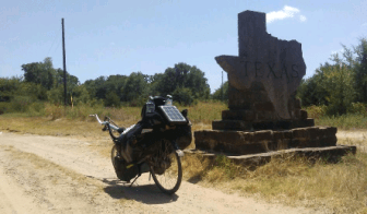
What I hadn’t noticed on the map was that the river wasn’t any ordinary river – it was the Red River, the squiggly border between Oklahoma and Texas. I was now in my last state of the USA!
Almost 10 hours after leaving Atoka, I finally got to Bonham – but even finding somewhere to stay wasn’t simple. Now that I wasn’t on the main route any more, I was away from the motels, restaurants or shops. I didn’t have the energy to shop around , so decided to just stop at the first place I came across. This turned out to be a very new Holiday Inn Express – a far cry from some of the very dodgy motels I’d been staying in recently. It was more expensive than I was hoping for, but the receptionist obviously felt sorry for me as I got a suite for the price of a basic room. It might not have been quite the rest day I’d been looking forward to, but I was going to have a comfortable and sound night’s sleep! I think I deserved it 🙂


Phew – thank goodness for the update. I’d been fighting the temptation to phone A&B for news.
Would you consider more frequent posts, just to say “still alive and in one piece”?
You certainly are seeing the world in a very unique way; I’m full of admiration. Keep up the good work, and remember most Mexicans are nice folks.
cheers Mo
LikeLike
Yes, sorry about the gap – updating the blog has been surprisingly time consumming! Time well spent, but I couldnt do it while Sue was here – she wouldnt have been impressed.
LikeLike
I’ve got a new GPS tracker (the old one was a bit temperamental) and you can view my progress (or lack of!) on this web page: http://share.findmespot.com/shared/faces/viewspots.jsp?glId=0l7imKPgIxqYP28q82lNmPoMlLGvqHT4o
As for the Mexicans, I am expecting most of them to be good people. Speaking to different people there is quite a range of views about the situation in Mexico – most of the old white males think I’ll be gunned down by a drug cartel sniper as soon as i step out of passport control! I am slightly aprehensive (mainly down to my spanish not being great) but am sure it will work out fine.
Hows are things with you?
Hope you are well,
Keith
LikeLike
You’ve nothing to fear in Mexico. Nothing, absolutely nothing, is as scary as the ‘Museum of Creation Truth’. You should’ve gone in – they’d probably warn you about cycling off the edge of the Earth!
LikeLike
Thanks for that – crossed the border yesterday, and its all a bit of a culture shock!
LikeLike